Artificially intelligent road safety
Ford develops new road safety dashboard
Some roads require greater attention. That’s the view of Ford who have developed the “RoadSafe” concept.
This new facility can alert drivers to higher risk locations. Alongside this, the data accumulated about high risk areas can be shared with local authorities in order to encourage them to do something about them.
Artificial intelligence
Ford’s “RoadSafe” technology uses a ‘smart algorithm’ to crunch anonymised data from sources including connected vehicles, roadside sensors and accident reports. This is used to pinpoint where there is a higher chance of traffic incidents occurring. The information can then be displayed on a map that identifies the level of risk and could also be used to warn drivers of hotspots.
“There are areas in every city where the chance of an incident is higher, whether it’s due to a poorly placed sign, an unrepaired pothole or junctions built to accommodate far less traffic than we have today,” says Jon Scott, City Insights project lead, Ford Mobility Europe. “Ford can pinpoint the areas of concern, so drivers could be made more aware of them and authorities can address them”.
Safer roads for everyone
The “RoadSafe” digital tool is the culmination of four years of research by Ford. This includes a recent 20-month government-funded project conducted together with Oxfordshire County Council, Loughborough University, TfL, Innovate UK and AI sensor specialists Vivacity Labs.
The research began with an analysis of Greater London highlighting road safety hotspots. Potential causes and safety mitigations could then be highlighted. In the last 15 months, the research expanded to Oxfordshire.
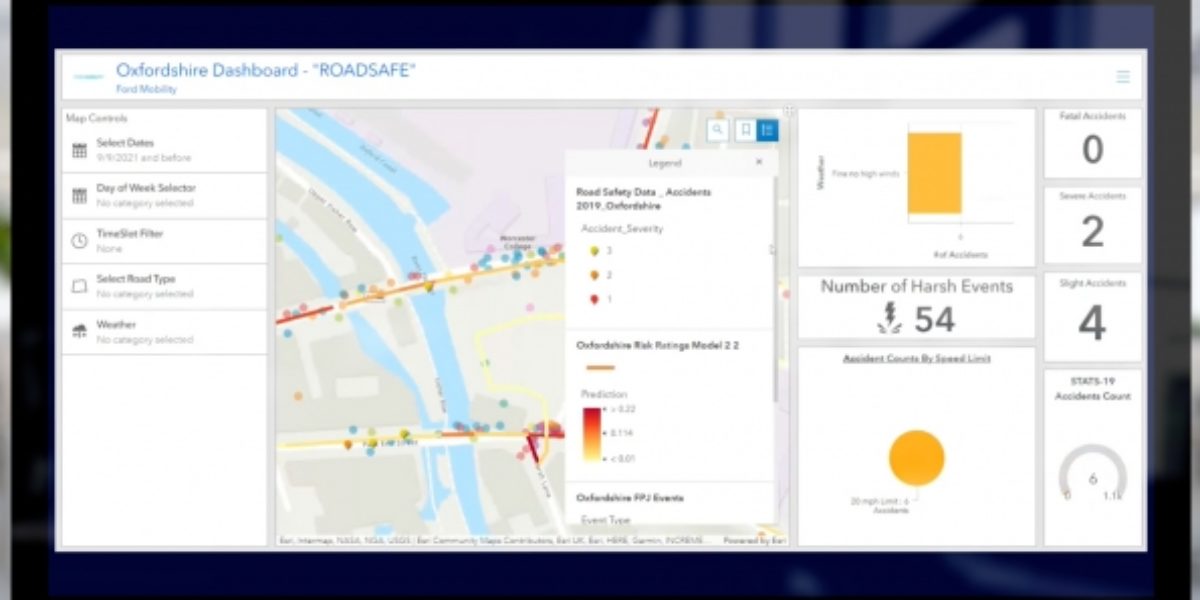
More than 200 passenger and commercial vehicles voluntarily connected in London and Oxfordshire. The data enabled the team to develop a “Road Segment Risk Rating Heat Map”. This identifies stretches of road that are of particular concern.
Driver aid
The resulting dashboard includes various layers of data, including historic accident data. A “Risk Prediction” rating algorithm for each road segment based on a range of data inputs calculates risks. The “Road Segment Risk Prediction” rating uses colours to show where incidents are more likely to happen, with red indicating the highest risk level and yellow the lowest.
To gather the data, the connected vehicles record driving events, including braking, steering and accelerating. Meanwhile, Vivacity’s road-side sensors track the movements of different modes of transport.
The sensors employ machine-learning algorithms to detect near-miss incidents, analysing movement patterns of vulnerable road-users as well as non-connected vehicles. All data shared by the sensors is anonymised.
Plotting the route ahead
Combining vehicle and sensor data can help identify a wide variety of hazards. For example, places where vehicles pass too close to cyclists, or a poorly located bus stop. Badly designed infrastructure such as a roundabouts and junctions causing confusion and near-misses are also highlighted.
“RoadSafe” could be used to optimise route planning. These could avoid particular problem areas, or warn drivers about greater risks. Universally applicable and scalable for areas ranging from large cities to small towns, “RoadSafe” could have a significant impact on the number of road incidents.
In the future, such technology could also benefit passengers riding in autonomous vehicles. Combining the on-board sensors of the vehicle with a digital tool could help them anticipate hazardous situations even earlier and therefore adapt their operation accordingly.